.
.
.
In this Tuesday’s Anaheim City Council Public Hearing on districting, is Lucille Kring’s home bound for whiter ground?
We’re close, now, to seeing whether the Anaheim Districting process is going to have a smooth glide path to completion or will hit major turbulence on the approach to landing. The first of three Public Hearings by the City Council will take place next Tuesday, October 20; the second will take place four weeks after that on Tuesday, November 17; the final one will be three weeks after that on December 8.
That’s 50 days, inclusive, from start to finish. But the first of those 50 days may be decisive.
Here’s the Staff Report for what will be Agenda Item 19 for the Council Meeting:
ITEM # 19 RECOMMENDATION:
That the City Council conduct a public hearing regarding formation and boundaries for six City Council districts to be reflected in a districting map, consider which four districts will hold elections in 2016 and which two will hold elections in 2018 and provide direction to staff regarding preparing an ordinance for these and related matters.
BACKGROUND:
On October 6, 2015 the City Council received the Final Report of the Advisory Committee on Electoral Districts (“Committee”). The full Final Report, including attachments thereto, is appended to this staff report as Attachment 1. The Final Report was unanimously approved by the Committee and recommended the City Council adopt a districting plan identified therein as Map 3, as revised (see Public Submission Tab #P31, see also Attachment A of Final Report). The Committee recommended districting plan is termed herein as “Recommended Plan (Map 3).”
SUMMARY OF POTENTIAL COUNCIL DIRECTION/ACTION
Following testimony and discussion at tonight’s public hearing, the Council may choose to direct City staff regarding two primary decision points (discussed in more detail below). Staff recommends that the Council give direction on these decision points in the following order:
- First, the Council may choose to direct that the City Attorney prepare an ordinance establishing a particular districting map (for example, Committee Recommended Plan (Map 3)) for consideration and introduction/adoption at future scheduled hearings.
- Second, the Council should discuss and identify which 4 districts should be up for election in 2016 and which 2 districts should be up in 2018. The Council should then direct that said selected district election dates be included in the ordinance being prepared.
SUMMARY OF PUBLIC HEARING PROCESS
This is the first public hearing in a series of at least three noticed public hearings that the City Council will hold consistent with state law (Cal. Elec. Code § 10010(a)). After tonight’s hearing, two public hearings will follow on the dates noted below. The final public hearing will be held to approve a proposal to establish district boundaries.
In addition to this evening’s hearing, public hearings have been noticed for November 17th and December 8th.
If, after conducting tonight’s hearing, the City Council prefers a particular district boundary map, the Council may direct the City Attorney to prepare and return to the Council with an ordinance adopting the preferred map. In that case, an ordinance would be presented and could be introduced at the second public hearing on November 17th and thereafter, scheduled for approval at the third public hearing on December 8th.
If tonight’s hearing does not lead to Council direction on a particular map then more than three meetings would be required in order to be consistent with the statute summarized above.
SUMMARY OF LAWFUL DISTRICTING CRITERIA
A number of legal requirements relate to the creation of district maps/boundaries. The 14th Amendment to the United States Constitution requires that districts be as nearly equal in population as possible. State Supreme Court opinions and state law require that total population be used for creation of districts. See Calderon v. City of Los Angeles (1971) 4 Cal. 3d 251; Cal. Elec. Code 21620. For the purposes of establishing City Council districts, this means that the districts being mapped need to contain nearly equal numbers of inhabitants.
Elections Code section 21620 also states that in establishing district boundaries, such boundaries must comply with the all applicable provisions of the Federal Voting Rights Act (42 U.S.C.§§ 1973 et seq.) and the Council may also consider additional factors such as:
- Topography;
- Geography;
- Cohesiveness, contiguity, integrity, and compactness of territory; and
- Communities of interest of the districts.
California and Federal case law allow other criteria to be considered. The criteria enumerated in the California constitution that must be used by the state redistricting commission for redistricting of California’s state legislative and Congressional seats does not apply to local districting by cities.
CONSIDERATION OF DISTRICTING PLAN
Following the public hearing on this matter, the City Council should discuss one or more districting plans. The Council retains discretion, pursuant to the City Charter, to select the Recommended Plan (Map 3), make modifications to that plan or select another proposal. The demographer consultant will be present to address any questions regarding the maps or any modifications.
The October 6, 2015 staff report (included herein as Attachment 2) summarized the process undertaken by the Committee to reach its recommendation that the City Council consider adopting the Recommended Plan (Map 3). Key considerations and communities of interest that related to the Committee’s focusing on certain maps included the following:
- Total population equality (as required by law) and minor deviation from population equality (as permitted by law), particularly with respect to the district boundary line between Districts 5 and 6 (which on maps of focus is the western boundary for the district including far east Anaheim). Population deviation in the Recommended Plan (Map 3) is 1.4%, which is well within the legal standard of permissible deviation.
- Compactness and contiguity of districts, particularly in connection with considering obvious demarcation of east-west boundaries for districts.
- Using Euclid Street as a boundary between the two districts in the west and the other districts and use of Magnolia Avenue, East Street and State College Boulevard as significant dividing lines for other central City districts.
- Keeping cognizable communities of interest and neighborhoods cohesive, such as elementary school attendance areas, the Arabic business community in western Anaheim, the Colony, the Ponderosa neighborhood and residential areas of west Anaheim.
- Compliance with federal Voting Rights Act requirements.
- Dispersal of the Resort District and Platinum Triangle into multiple districts.
Pages 7 through 12 of the Final Report provide detail on Recommended Plan (Map 3)’s characteristics and the rationale for the Committee’s unanimous recommendation. The Final Report’s Executive Summary describes Recommended Plan (Map 3) and the Committee’s rationale for recommending this plan as follows:
“The Plan [Map 3] has a total population deviation of only 1.40%, with all deviation justified following major roads and keeping communities of interest intact. It is a contiguous plan that strongly considers compactness, particularly in light of the elongated shape of the city. As the Plan description below details, it carefully delineates between communities of interest as articulated in testimony during our public meetings. The Plan utilizes natural and man-made boundaries that are logical and easy to follow. This Plan carefully addresses voting rights and gives minority groups, particularly the large Latino population, with significant public testimony indicating that the Plan gives the opportunity to elect candidates of their choice (this is also discussed below in more detail). Finally, we heard a substantial amount of support for this Plan from many individuals and groups from throughout the city, including support from those that had submitted “competing” maps, including maps that were in the final grouping of maps considered by the Committee (i.e., supporters of Map 1 and Map 2 before the Committee).” (Final Report at p. 2.)
Potential Council Direction: To take action on establishing Council districts and move forward with a specific map, the City Council will need to make a motion directing the City Attorney to prepare an ordinance adopting a particular district map plan and boundaries. If this direction is given tonight, the City Attorney and demographer will prepare an ordinance with the district map requested for introduction at the next public hearing.
CONSIDERATION OF ELECTION DATES FOR DISTRICTS
It is necessary to establish the election dates for the six City Council districts. The City Charter requires that in 2016, four City Council districts be placed on the ballot for election. The remaining two districts will be up for election in 2018. It bears noting that the Charter specifies that following the swearing in of those Council members elected in 2016, one of the four districts will be randomly chosen to have only a two-year term of office. The random selection for a short term is required by the Charter to transition to an increased size of the City Council, so that 3 seats (excepting the Mayor) are up for election every two years after 2016. The City Council has the sole discretion to determine which districts are placed on the 2016 ballot.
Potential Council Direction: The Council will need to give direction to staff as to which 4 districts it desires to have on the November 2016 ballot, the remaining two districts would then be up for election on the November 2018 ballot. Direction on this aspect will be included in the ordinance. If direction is not given at the time a preferred district plan is requested for inclusion in an ordinance, such direction will need to be given no later than when the ordinance is introduced.
IMPACT ON THE BUDGET
Funds sufficient to take action on this matter and to interact with the Registrar of Voters to implement districting are included in the City Clerk’s FY 2015/16 budget.
Respectfully submitted,
Linda Andal, City Clerk
Michael R.W. Houston, City Attorney
Attachments:
1. Final Report of the Advisory Committee on Electoral Districts to the Anaheim City Council, including attachments as follows:
A. Committee Recommended Plan
B. Correspondence received by Committee
C. Proposals submitted by public and draft sample plans by demographer (Consultant Drafts #C1-C5; Test Maps #T1-T2; Public Submissions #P1-P32)
D. Committee agenda, staff reports and minutes
E. Samples of public outreach
2. Correspondence from League of United Latin American Citizens; and Orange County Communities Organized for Responsible Development, on behalf of various community organizations
3. October 6, 2015 City Council Staff Report for Receipt of Final Report (without attachments)
I’ve highlighted in orange the items of note.
First, under “Summary of … Process”: either the final choice of a map has to happen on Tuesday — or else. (Or else what?) Or else there would have to be a fourth public meeting. (That’s doesn’t sound like such a big deal.) It may not sound like a big deal, but it’s the holiday season and they want to avoid this. Once they choose a map, they write up the ordinance; after that it goes through two readings. Those, unless they want to have more than four meetings in total, will probably be pro forma. Even if a bare majority of the Council wants a particular map on Tuesday, that coalition would presumably hold together through the end. Of course, if they mess around too much, litigation would still be a possibility.
Second, under “Summary of … Criteria”: I have argued since Day 1 that while the criteria approved by the voters in approving the initial districting initiative may not apply to the City, the City should decide to adhere to it voluntarily as representing a “best practice.” The point at issue is whether they can fiddle with the maps to, for example, change lines to serve an incumbent’s (or expected challenger’s) interest in being in a given district given the location of his or her residence, or to serve partisan gain. (The redistricting done by the Orange County Board of Supervisors, which was also overseen by Ben DeMaio, was criticized along these grounds.) The section highlighted in orange is the Staff’s rejection of that view and stating that the City can do whatever it wants.
Third, just under “Consideration of … the Plan”: this is a pointed reminder that the Council does not have to select the Recommended Plan (previously “Reyes Map 2.”) It can tweak it lightly; it can replace it entirely. If it plans on wholesale replacement, it would be odd if a plan had not already been prepared and seen by at least one or two Councilmembers, with a third ready as usual to vote in concert with them. If it’s a tweak, it’s possible that — however well-rehearsed — it may come up from a Council member; but there, it would be surprising if it didn’t first come up in Public Comments. If you see a bunch of interest groups speaking up for some tweak, you can presume that “the fix is in.”
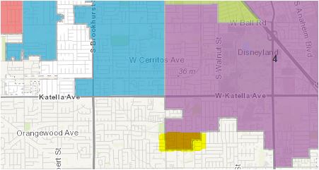
Fourth, under that same section: the two paragraph above are likely to raise an issue primarily with respect to whether Lucille Kring’s house, which I’m informed is southeast of the intersection of Euclid and Orangewood. The area where she lives is highlighted in yellow in the graphic above, turning it sort of brown. She would prefer that it somehow be scooped out of the (purple) District 4 into the (blue) District 2 — which currently stops at the Euclid border from the north to south boundary of the City. That’s why the decision to use Euclid as a boundary is highlighted. District 2 is substantially whiter than District 4, which is entirely east of Euclid. One must snake down through lots of territory to include this chunk — and there’s no good reason to do it other than to save Kring from being voted on by Latinos. Several maps initially presented by the public did make this odd move, despite its wrecking an otherwise pretty intuitive division of the city at Euclid. I have no proof (at this point), but it seems likely that the demand for this odd bit of gerrymandering came, most likely through intermediaries, from Kring. Would changing the map on that basis it lead to a lawsuit? It might. Would a majority rejecting the Judges’ recommendation to give into one council member’s aversion to representing a substantially Latino electorate be totally outrageous? I think that it’s fair to say that it would.
Finally, while I’ve been focusing mostly on lines, various sources say that the last highlighted point is likely to be the one where the Council can most effectively use its power to shape the next three elections. They will choose two districts to not have elections during 2016; after the election, chance will then add the third. While many of us have thought that the two districts occupied by incumbents Murray and Vanderbilt would obviously be the two choices, it ain’t necessarily so. (This is probably a good moment to point out that I don’t actually know which district Vanderbilt lives in. I think that it’s in District 3, but I believe that it’s pretty close to the intersection of Districts 3, 4, and 5 at East and Santa Ana — and it could be in any of them. Or, of course, he could move. Moral: watch for “tweaks” around there!) Unless she has moved recently, Murray definitely lives in District 6.
The City’s position, as I understand it, is that Murray and Vanderbilt will not be representing a district at all during the next two years. They were elected at large; at-large they will remain. So, if there is an election in District 6 Anaheim Hills, which is most of , and Districts 2 and 4 have no 2016 election, then Murray and Vanderbilt would just both be responsible for representing all of Districts 2 and 4. So, if they really wanted to disadvantage Latino voters, one would expect to see the Council choose the two most Latino districts — 3 and 4 — to not have elections in 2016, so that they could spend two years being represented by a couple of white Republicans. (Actually, I’m told that Vanderbilt does have a claim to half-Latinoness, although not to Mexicanity. Kring has neither.)
This probably won’t happen, though, because not having an election in District 4 totally screws Lucille Kring — she’s literally have nowhere else to run unless she moved out of her house and into another district — and not having an election in District 3 would totally screw Fourth Mouseketeer Gail Eastman, unless she moved from her Colony residence. (Not having an election in the sole Latino majority district is also one of the moves that could possibly lead to a lawsuit.)
The Council is likely to choose District 5 to have no election for a very simple reason: in a Presidential election year, when turnout is higher, this — the district with the closest margin between Latinos and non-Latino whites under the Recommended Plan — the district is likely to lean Democratic and in non-Presidential years it is likely to lean Republican. So the Council will likely want to get it into a non-Presidential year. I don’t like it, but I can see it coming.
The other district to be spared an election is likely to be whichever one Connor Traut does not live in, so that the Council majority can get young Traut onto the fast track to City Council. I think that he lives in District 1, but I’m not sure. If Jordan Brandman feels like he may drop out of the Congressional race and will want to get back onto Council, but he doesn’t want to run in District 3 (which also contains Dr. Jose Moreno), then the Council would do the opposite. This would ensure that Jordan could run in the Presidential year and still leave room for Traut to run in 2018 (which would require him giving up his seat on the Centralia School Board.)
So that’s the machination by the Council majority that we’re most likely to see on Tuesday. Hopefully, fiddling with which race happens when — which only has an effect for the next three races anyway — will be enough to satisfy their desire to fiddle.
Obviously, we will know a lot more about what has been going on with this districting process behind the scenes by meeting’s end. See you there!
Leave a Reply