.
.
.
Two of the three maps that are still officially in consideration for the retired judges’ Advisory Committee on Electoral Districts — the Gagne 1 and Reyes 2 maps, both featured in this previous post and soon to be known simply as “Map 2” and “Map 3” — will be unchanged when they appear tonight. The third of the trio — Chuchua 4, which I drew using the advice and observations of Brian Chuchua and some other long-term Anaheimers — will be replaced (if the judges grant my request) by a new map, Chuchua 9, which I describe below. Then, because the pills hadn’t worn off (joke!), I drew a final map, which we’ll call Chuchua 10, which is a revision of “Reyes 2” rather than of Chuchua 4.
All that clear? Good. Oh, and the people from LULAC are threatening to sue the city if their new map is not considered as well. We’ll get to that last.
“Chuchua 9”:
The Consultant has already drawn a map of Chuchua 9, but I haven’t seen it yet, so we’ll have to go from my own poor MS Paint renditions of what I think it will look like and an approximation of what the stats would be.
First, let’s look at the area west of Euclid. We’ve offered another possibility for the judges to consider:
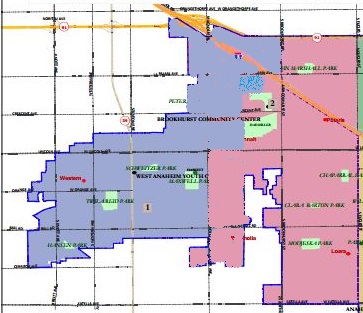
This addresses some concerns raised at the last meeting. The Brookhurst Community Center is moved into District 2 (in pink) with most of Little Arabia, while a portion of its Census Block Group (the blue stippled section) would remain in District 1. The numbers turn out quite well given this latter adjustment of 422 residents, with Districts 1 and 2 ending up with 28 and 34 residents over a perfectly equal distribution. Also, this map lacks the “thin neck” that makes some of the other maps using this general approach unattractive. This looks somewhat defensible.
Now as for the contentious area east of Euclid and west of the Anaheim Canyon, Chuchua 9 does this:
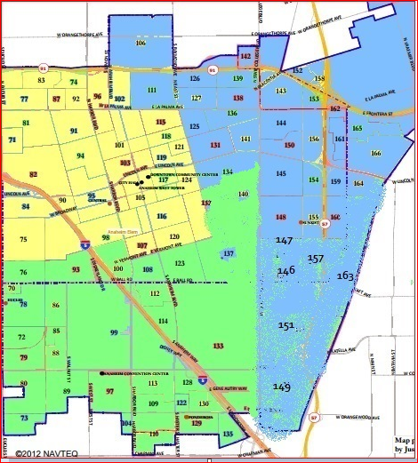
(Pardon my use of “spray paint” here; Photoshop still isn’t working so well.) This map — with District 3 in yellow, District 4 in green, and district 5 in blue — is, I submit to you, a nicely compact, non-gerrymandered, and logically intuitive map. It also joins the Reyes 2 map in splitting the Platinum Triangle from the Resort District — albeit by State College rather than Lewis Street.
Its final numbers are pretty spectacular regarding equality: the six districts, in order, are at 34, 28, -122, -133, -142, and 336. Total deviation probably right around 0.9%.
Regarding the ethnic/racial composition of districts, prior to moving around about 1700 people, the numbers looked like this (and probably won’t change all that much) — once again with the Latino CVAP % for each district followed by the Latino vs. White margin (which may be positive or negative) in parentheses:
District 1: 30.4% (-7.9%)
District 2: 32,5% (-4.9%)
District 3: 51.5% (19.7%)
District 4: 45.3% (9.4%)
District 5: 44.8% (7.1%)
District 6: 15.6% (-47.1%)
If you check the post from right after the previous ACED meeting, I think that you’ll see that this compared favorably to the Reyes 2 map when it comes to the all-important margin in the third-best district for Latinos.
“Chuchua 10” (revision of Reyes 2):
This would use the same map as above, west of Euclid. East of Euclid, the middle three districts look like this:
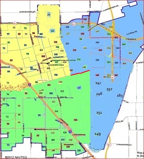
This one, if anything, looks even more clear. It now makes South St. the boundary all the way from the freeway to State College — one can’t get much more intuitive than that! After those cuts, though, about 1100 people would need to be transferred from District 4 (in green) to District 3. The most likely area would be from where you see that stippling of red dots west of the 5 (although it might reach up a little higher than I had thought in the part closest to the freeway. This could make a significant difference in the numbers — and unfortunately I haven’t been able to obtain the breakdown of population within the districts, and the associated statistics, over the past week. Sadly, it needs a little work, but the map is so “clean” that a few small transfers would be unlikely to mess anything up too much.
As a revision of the Reyes 2 map, it also splits the Platinum Triangle from the Resort District — once again, at State College rather than at Lewis Street.
As I haven’t had a chance to go through a final round of tinkering, its final numbers regarding equality are not as impressive: the six districts, in order, are at 34, 28, -496, -462, 440, and 336. Total deviation would probably be right around 1.7% — which is still pretty good.
Regarding the ethnic/racial composition of districts, prior to moving around about 4000 people, the numbers looked like this — once again with the Latino CVAP % for each district followed by the Latino vs. White margin (which may be positive or negative) in parentheses:
District 1: 30.4% (-7.9%)
District 2: 32,5% (-4.9%)
District 3: 50.1% (17.0%)
District 4: 45.2% (9.7%)
District 5: 46.1% (9.1%)
District 6: 15.6% (-47.1%)
Again, these would change a bit as the populations shift — and bear in mind that that district 3 number (or one of the others) has to stay up above 50.000%. But keeping that number so low, if it can be maintained, would mean that both the second- and third-best Latino districts would be between 9% and 10%. And that is something that would be pretty much impossible to beat with a map that looks as non-gerrymandered as this.
If you want to learn more about the LULAC map and the challenge it poses to the Committee and the City, go back to the most recent post before this one, figure out how to find the agenda, and read the LULAC letters and about the LULAC maps. You’ll see why I don’t favor them — not only do they cross Euclid and look as gerrymandered as hell — but they create two districts with huge Latino advantages and four districts with Latino minorities. And that locked-in minority status, many of us believe, was not what the people who brought the lawsuit that led us to this districting process had in mind!
Did LULAC advocate fore the AVLS or The EASTSIDERS?
What a joke.
I would have trashed this comment from – I guess you all might as well enjoy this – “fernanda@tacobell.com” (see how witty our racist anonymous commenters are?), but Vern got to it first. So congratulations to whoever was temporarily writing from 64.113.218.70 for slipping one by. Apologies to LULAC, which certainly doesn’t deserve this sort of puerile crap.
I never said I was down with censoring comments just because they’re ignorant, racist and anonymous. To get rid of all of those means giving up on getting a complete picture of what the blog public is really like out there.
No, of course LULAC is very far from being any kind of gang apologists, in fact they’re much closer to the police.
LULAC is a paper tiger.
LULAC worked on this map with MALDEF, which does have an established and successful track record of lawsuits against gerrymanders that wrongly disadvantage Latinos.
But this ain’t one of those, and I believe that the people from LULAC understand that. They disagree, in part, but — having talked to them last night — I would not expect a lawsuit against the Reyes map.
Now if the council were to do something really strange when they consider this map, some sort of strong legal response would not surprise me. MALDEF does some great legal work.
Wait. I did post that from TACO BELL!
Hope you enjoyed it. Buh-bye.
Taco Bell which sucks by the way with its powdered beans and “meat.”