.
.
.
The final stretch of the judges’ Advisory Committee on Electoral Districts portion of the Anaheim’s Districting process kicks off tonight at 6:30 in City Hall. The public is invited to attend. My grand plan to complete all of the analysis of the 25¼ maps under consideration (in whole or part) by tonight did not succeed due to various factors (including preparation for CATER’s big fundraiser tomorrow night and seriously cool climate change discussion at Servite H.S.), but we can still finish enough of it to give us plenty to discuss.
To allow latecomers to catch up: Part 1 of this series simply set forth all of the maps under consideration as well as their attending statistics. (It has been getting a decent amount of hits despite a lack of comments, so OJB is happy to have provided a public service). Part 2 of this series introduced the spreadsheet that can be used to compare those maps on various grounds, noting the number of Latino majority and plurality districts (using various criteria for “plurality”) that each creates. Part 3 of this series explored different ways that different maps try (to the extent they do) to foster Latino participation in the Council and noted some problems with maps that create two strong Latino pluralities — but no third one of any kind.
This was originally going to be two separate posts, but they sort of fit together, under the title of “Deviations.” Let’s start with the mathematical deviations first.
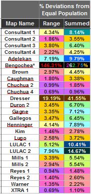
The left column shows the sum of the absolute values of highest positive and negative deviations among each map’s districts. The right column shows the sum of the absolute deviations for all six districts. Purple is lowest and blue is highest (except for the two outliers.)
[1] How Far From Ideal?
The graphic at left shows us how much each listed map deviates from an ideal one, in which each of the six districts has 56,044 residents. The “Range” column takes the value of the highest positive deviation (i.e., how much more than 56,044) and adds it to the value of the highest negative deviation (i.e., how much less than 56,044.) The “Summed” column does the same, but for all six districts.
The Consultant uses only the “Range” figures in his report to the Advisory Committee. As I recall, he has said that for these purposes he considers a range of up to 4% to be acceptable (and presumably a little bit beyond that.) By that standard, only the Adelekan, Bengochea, Dresser, and two LULAC maps don’t qualify. My rule of thumb is that if the Sum column is more than twice the range, that’s a sign that too many districts have discrepancies. Generally, a positive discrepancy would be considered the hurt the residents of a district and a negative discrepancy helps them; determining whether certain maps hurt or help minority communities more than others is left as an exercise for the reader.
The consultant has conveyed that he considers the degree of deviation-lowering seen in the Chuchua and Reyes maps (including XTRA 1) to be unnecessary. It probably is — but it doesn’t hurt anything and it helps the cause of equity at least slightly. The problem with it obtaining deviations this low is that it usually comes at a cost in terms of compactness or respect for communities of interest. Notably, the Chuchua maps are probably the most compact of any in the running, with its main deviations from compactness coming from the incorporation of the Ponderosa map into Chuchua 4 and XTRA 1.
But how much does minimizing deviations really matter? That takes us right into Part (2)
[2] What Exactly is the Judges’ Task?
I recall looking up the “charge” of the committee early in the process — and then for the most part forgot about it. I looked it up again recently while preparing this post.
We can find the basics on this page:
The City Council has appointed five retired superior court judges to serve as the city’s Advisory Committee on Electoral Districts. The Committee will hold public meetings, listen to public testimony, and receive information from staff and a demographer. The Committee’s purpose is to assist in the development of district maps; at the conclusion of the public meetings, the Committee will submit a final report to the City Council on the proposed districts, by October 6, 2015. The City Council will have the final vote on city districts, which will be preceded by at least three (3) public hearings.
But the really interesting material is on this page:
The Advisory Committee will base its recommendation on federal and state laws, as well as any lawful districting criteria established by the Anaheim City Council. The U.S. Constitution requires districts contain roughly equal population and the Federal Voting Rights Act prohibit racial gerrymandering. In establishing the boundaries of the districts, the Committee and the City Council will give consideration to at least the following factors:
• Topography
• Geography
• Cohesiveness, contiguity, integrity and compactness of territory
• Community of interests
So, break them down, and you have seven factors (as the third bullet point above has three parts) that are mentioned in the governing state law, California Election Code Section 21500:
- Topography
- Geography
- Cohesiveness of territory
- Contiguity of territory
- Integrity of territory
- Compactness of territory
- Community of interests
What’s the difference between those first two categories? Glad you asked!
Geographic criteria can be divided into two categories–criteria relating to geographic boundaries and criteria relating to geographic size and/or shape. A boundary authority may be asked to consider factors from either or both criteria. …
Respect for clearly established boundary lines is often specified as a criterion for those redistricting to consider when drawing electoral district lines. These boundaries can include administrative boundaries such as county and municipality lines and/or natural boundaries created by dominant topographical features such as mountain ranges, rivers or islands.
“Topology” will generally be “the lay of the land” as it is now exists. For example, the fact that West Anaheim and Anaheim Hills are both peninsulas. The 5 freeway, major thoroughfares (roads), the inlet of the unincorporated Anaheim Island, the river, etc. provide obvious boundary markers, although these can work at cross purposes. (Do residents in the southernmost part of the strip of Anaheim east of the 57 really have more in common with those who live all the way up in Anaheim Canyon than they do with people who live just on the other side of the freeway? Probably not.) “Geography” would include the lines we add to that that you couldn’t see from an aerial view: administrative districts like the neighborhood councils, school districts, parks, proximity to neighboring cities — to the extent that people really care about any of that.
“Contiguity” means that, if one chose, one (at least if one is a bird) has to be able to travel from each point in a district to every other point in the district without going over another district. Because the districting program made available to the public did not include sample graphic previews of one’s districts, I learned that this was an absolute requirement for the City the hard way — by making repeated coding errors that the Consultant was nice enough to fix. (Seriously, Council: next time spring for software that generates previews — or at least warns mapmakers if a part of the may isn’t contiguous!)
“Compactness” means that a district is better to the extent that travel between all of the different parts of a district takes as little distance (if you’re a bird) and also time (if you’re a human, as you are) as possible. Judging compactness by distance vs. time is a fun argument for people making maps. The clearest case would be something like: you wouldn’t call a map joining together two spots on opposite parts of a river “compact” if the closest bridge usable to cross the river was many miles away. This becomes an issue for parts of the 5, 57, and 91.
“Cohesiveness” applied to people would fall under “communities of interest”; for territory, it would seem to mean more like common uses, etc. To the extent that one has a choice between drawing a line between a gated community and a non-gated area, one would tend to split them rather than put some of each in each district.
“Integrity” this term gets thrown around a lot but rarely defined. I suppose that a district shaped like a jack might lack it.
“Community of Interests” are whatever people in a given area believe binds them together — or, less frequently, keeps them apart. There is surely a line somewhere that would best separate fans of Anaheim High School teams from Katella High School teams. If this was really what people in that area cared most about in defining themselves, that could represent a “community of interest.” Each might want to be in a district with other fans of the same high school. But it’s unlikely that many would feel that strongly about being kept out of a single district that included both fans of Katella and Anaheim high schools. (Or maybe I’m overestimating people.)
So overall, we can see that the Judges are to concentrate on what brings people together. What concerns me is the idea that they may feel that their charge also includes putting similar people into separate districts for purely political benefits. That’s not in their charge from Measure L — but it’s not entirely clear that all of them agree.
[3] Are the Judges Supposed to Split Districts in Order to Enhance Their Political Power?
I’ve been impressed with what I’ve seen with how Judge Edward Wallin — the sole Anaheim resident on the panel of five — presides over the meetings I’ve attended. But there’s one statement he made — seemingly a very impactful one — that gave me substantial concern.
You can read the summary of it in the minutes of the June 9 meeting, held in Anaheim Hills:
[Judge Wallin] also requested Mr. Levitt [the consultant/demographer] consider how to handle the Resort District and its impact on the City, potentially being in more than one but less than three districts.
Both the Consultant and many of the rest of us hopped-to, trying to see what would happen if one divided the Resort District — stretching from Disneyland and the Convention Center east to Angels Stadium and the Honda Center, along with hotels and motels between and among — into two (or more) districts.
I found that it created a lot of problems if one wanted to boost Latino participation and if one wanted to lower deviations as much as possible. (I have no doubt that the Judge had neither of those intentions in posing the question. It was a surprise to me too.)
But I had another problem with the question as well, which you can see in the video on this page, the relevant portion of which I’ll transcribe. Judge Wallin speaks at the end of Public Comments, with all but the part I’ve placed in bold being entirely well-taken:
Judge WALLIN (43:48): I think that the job of collecting all these maps and all this information is what Justin is going to be doing. That’s his task; I suspect it will take him many hours, because we’re looking for your information. The maps and things that people hand in or the information they convey is all going to be taken into consideration. Justin, I assume it would be helpful to you if the Committee could provide some criteria for you to follow. Do you agree with that?
Justin LEVITT (44:25): Yes, because July 1 we’re going to be presenting maps, it would be useful for you to explicitly list out some of the criteria, or the criteria you’d like me to follow, as well as give direction on particular communities of interest. These will be for draft proposals, not for final proposals. So anything you request will be subject to many rounds of change. But it would be good to get that conversation, or get some explicit direction going forward moving to the maps.
Judge WALLIN (45:57): I know that you understand this, but everyone should understand that the primary endowment and consideration is to have equal population numbers in each of the six Council districts being drawn. And then of course we must comply with the Federal Voting Rights Act, concerning providing consideration for ethnic and language minority groups.
And we also have other issues that you’ve already mentioned, Justin: the contiguity of each district; the geography of the City, including the natural and man-made boundaries such as freeways, rivers, creeks — anything that divides a neighborhood we have to consider, to see, if that makes the neighborhood on one or the other side different and should it be held into one district. So we’ll be looking at communities of interest, and I know your demographic data goes a long way toward providing that information.
We also want you to consider the testimony at the public meetings, including this one, and the written submissions we’ve received from the public, including also at this meeting. We do expect that you should consider all of this data and develop at least some tentative or proposed maps for us to look at, and for the community to look at, at future meetings.
(46:38) I think that we also have to consider how to handle the Resort District. Because it’s going to be true that multiple Council districts will probably take in part of the Resort District or at least touch to it. And that’s obviously a key part of the City of Anaheim. You know, all of us who live in Anaheim should be proud of our city. It wasn’t Newport Beach, it wasn’t Santa Ana, it wasn’t Orange, it wasn’t the county, that brought all the things that make the county exciting. I’m thinking of Disneyland; California Adventure; the Convention Center, which brings a tremendous amount of business; and the Ducks hockey team; and of course, since I’m a baseball fan, especially the Angels. But we have those things in this community nowhere else, and we have to consider the impact of that Resort District when we prepare maps. So I think you’re going to need to draw maps that take in and measure the Resort District probably into more than one — probably not more than three — of the districts.
Other than that, would anyone else on the Committee like to add some considerations that they think are important?
Since I was sitting in that meeting on June 9, somewhat distracted by my trying to sort papers into a form worth submitting to the Committee, I haven’t replayed that video until today. My thought at the time was “seriously, Judge, the Resort District has shown that it is perfectly capable of taking care of itself.” But in thinking about it over the past 50+ days, I’ve had another reaction, for which I’ll start a new post:
Was that really any of his business as a member of the Committee?
I don’t think that it was. And I think that it has caused problems. More in Part 5.
Unlike the (In)famous Disney-manufactured government entity of the Reedy Creek Improvement District in Florida, do ANY registered voters actually LIVE in the Resort District ? I would think not, and had submitted a suggestion to the Committee (unresponded) that ALL non-residential areas (City parks and schools, Anaheim Canyon Industrial park, etc.) be uniquely shaded or colored on the maps, for exclusion to perhaps clarify and more easily HELP bound “communities of interest” ACTUALLY CONTAINING REGISTERED VOTERS. The gushing “civic pride” of (46:48), so evocative of similar lengthy and irrelevant diatribes from other meetings held (Tuesday nights) on the dias, seems to increase my cynical suspicion of process movement backward from a goal rather than forward toward one.