Unless you want to do something really weird, Districts 1 (Southwest, tinted orange) and 6 (Anaheim Hills, tinted red and cut into two along the dasjed black line) have nowhere else to go!
With the initial organization meeting out of the way, today is the first of three meetings where the panel of retired judges advising the Council on redistricting have their first meeting to gather information to the public. It’s at 6:30 at City Hall.
I can’t be there — partly because I’ve been spending too much time playing with their online redistricting tool — but I’m sending along a map along with these comments. Here are the three big findings:
(1) District 1 and District 6 (presuming that they number west to east and then north to south) are pretty much set. Each district has a target of 56,044 people (based on the last census.) District 6 (Anaheim Hills) gets to within 164 of that as it goes westward, which is pretty good — and it may get another block or two to make it better. When I put in what seemed to be the most reasonable districts for District 1 (Southwest Anaheim), one of my first guesses was off of the target by only 11 voters! Any change I tried to make from that — and it’s quite a logical district map as it stands, given the geography of that peninsula within the city — made it substantially worse. I think that it will be hard to argue for breaking up Southwest Anaheim beyond what I present here.
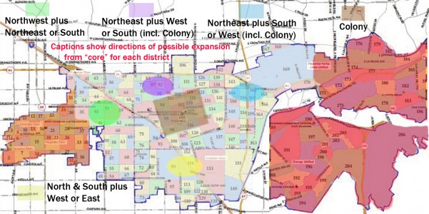
(2) The choices of where one puts the rest of the districts are pretty limited, unless you do one of two things that I don’t recommend: (a) break up the Colony (which is the City’s most coherent district and which I’ve tinted in light brown) or (b) snake a district along both sides of the Anaheim Island, which leads to a seriously ugly and hard-to defend leftover district in Southwest Anaheim. In playing with the figures, it looks to me like either the 5 freeway or Euclid Avenue are pretty good “natural boundaries” for maps, at least north of the Euclid interchange. (South of it, it’s very likely to be Euclid unless you do something very strange with the second westernmost district.)
(3) Avoiding “packing” or “cracking” of Anaheim’s Latino voters will be easier than I imagined. It should be possible to create one “minority majority” district (as is strongly suggested by law where possible) and of the other four districts, not counting that one and Anaheim Hills, the gap between Latino and Non-Hispanic White CVAP (Citizens of Voting Age Percentage) can be less than 10 points (two going in each direction) without straining anything. Asian and Other voters are the tie-breakers in all for plurality districts. It does not look possible, given residential patterns, to create a plausible Asian-majority or -plurality district unless we have a lot more districts.
(I should mention right here that I have not looked at partisan registration numbers AT ALL. I’m following the guidelines used by California’s Citizens Redistricting Commission in 2011, which say that partisan breakdown and residences of candidates should not be considered.)
As for the other four districts in between the “should-be-settled” pair, one will have its core north of the Colony District, one south, one east, and one west. One of those districts — probably the one containing either the purple or the blue oval in the map — will also swallow up the Colony itself. If you don’t want to divide the Colony — which has as better a claim to be treated as a unit than anywhere else in the city except for Anaheim Hills — then that substantially constrains what you can do. I’ve created a couple of maps, one putting the Colony in with the North district (purple) and one with the East district (blue) — and once you’ve made that choice the rest of what you can do is largely forced into place, presuming that you limit yourself to the Census Block Groups presented in the mapping software. Most of the expansion of the green and yellow groups is either pretty fixed (which I didn’t illustrate because I didn’t want to give the impression that these were full maps) or largely limited to going in one of two directions.
What I’d really like to see happen now is for the Advisory Committee to direct that maps be shared with the public as they are submitted. (As I recall, that’s how the 2011 state Commission did it.) That way, it will be easier to identify and comment upon what other mappers are doing right — and, inevitably, what some of them are doing wrong.
Have a good time tonight, if you’re going; wish I could be there!
*Whoever comes up with the final solution better offer a paint by numbers coloring book for every voter..eh?