.
.
.
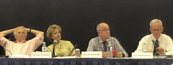
The Anaheim Committee on Electoral District: left-t0-right. retired Judges Hon. James Jackman, Hon. Nancy Wieben Stock, Hon. Edward J. Wallin (Chair), and Hon. Stephen Sundvold (Vice Chair). Not fitting in the frame: Judge Thomas Neal Thrasher. Photo courtesy of Nancy West.)
It was a hot night at Western High School. In the sweltering non-air-conditioned cafeteria, the retired judges of the Advisory Committee on Electoral Districts even, for the first time in performing their public duties, took off their coats. It was also a significant night for Orange County politics — with implications reverberating far beyond Anaheim.
Barring some unexpected zigzag by the City Council, two decisions made by the judges last night mean that the County’s first “by-and-for” city electoral districts are going to work. The consequences will likely be felt in Santa Ana and Newport Beach, as well as in the newly gestating districts in Fullerton and Garden Grove and in the yet-to-be mined territory of Huntington Beach and Irvine. It justifies the faith placed in the hands of smart and dispassionate people who have made a career out of quickly getting up to speed on tough and complicated issues.
I’ll declare my interest up front: the map on which I’ve worked in partnership with Anaheim resident Brian Chuchua, whose “Chuchua 4” map was one of the three chosen to go forward to the next stage in the decision-making process. That doesn’t mean that it will be the one that the judges recommend to the City Council; that honor looks likely to go to a map submitted by young Oscar Reyes, who has been enthusiastically supported by a throng of people from OCCORD, Anaheim’s Unite-HERE local, OCCCO, and other locally influential groups.
That result is OK with me. What matters is that with the two decisions implicit in the choice of the Chuchua and Reyes maps and the map submitted by West Anaheim’s Benita Gagne, the judges have assured that the final map will be a strong and fair one. Specifically, they have signaled the desired form and content of a final map — and how it should be evaluated. That’s very important.
The two decisions that were implicit in the choice of the “Reyes 2” map and its fellow candidates were this:
(1) The goal of the process will not be to generate two majority Latino Districts and a third-best with a weak plurality (as in “Chuchua 4” map) or no plurality at all (as in the Gagne map), but a map like the Reyes 2 map with one majority Latino District and two districts with strong-to-moderate Latino pluralities.
(2) Euclid St. will be the border separating West Anaheim from the eastern 2/3 of the City.
Taking point (1) first, that approach from the Reyes map is as it should be.
The only reason that the Chuchua 4 map doesn’t have that form — which the Chuchua 2 map did have — was that we decided to build the Chuchua 4 to incorporate the preferences expressed by the “Ponderosa community” for South Anaheim, which included a map with a small majority. I suspect that the Gagne map has a white plurality in the third-best district for Latinos primarily because Gagne was trying to ensure two majority Latino districts and that makes it hard to generate even a third Latino plurality district without drawing some convoluted lines. Now that the judges’ preferences are more clear — while they were not voted on explicitly, their changing their perspective on “2 at 50%” versus “1 at 50% and two strong pluralities” was evident in their comments — both Chuchua and Gagne can revise to go along with these more flexible standards.
Regarding Euclid St., the decision to take maps only using it as a divider is both a bold decision and the right one. While mapmakers have loved to draw lines crossing the city (and Euclid in particular) in order to get the best numbers — the LULAC maps and the Mills maps are good example of this — there is virtue in simplicity. My experience with presenting the Chuchua maps matches that of other map-makers: Euclid as a dividing line not only makes almost perfect mathematical sense — almost exactly 1/3 of the city is west of Euclid — but it makes great intuitive sense for citizens as well.
It also has the effect of making the districting process “mix-and-match” — the Committee can now work on the “west of Euclid” and “flatlands east of Euclid” maps separately. It already made substantial strides in this direction last night, identifying three different “west of Euclid” maps to consider, and later adding a fourth: “the aardvark.” (I’ll propose a fifth — “the llama” — below. I promise, this will all make sense in a few minutes or your money back.)
Having a map that “looks right” — that looks obviously non-gerrymandered — is an important means of obtaining the citizenry’s trust in and respect for the process. The fact that independent work by three politically disparate mapmakers — OCCORD is at the heart of liberal-left Anaheim, Gagne is the President of the very conservative Anaheim Republican Assembly, and the partnership between Brian Chuchua and me brings together a right-wing populist Republican with a left-wing local Democratic Party figure — testifies that this isn’t a matter of prospectice partisan gain, but of people from across the spectrum who just really want the process to be fair and the product to be successful. And part of that “success” is in having clear, obvious, intuitive divisions of the city.
Two main issues remain. (And some of our readers here will be pleased to know that I’m likely to lose on both.)
(3) How should we divide up the two districts west of Euclid?
There are a lot of ways to divide the western third of Anaheim in half: I think of them as the “bear” and “dog” methods — although, in one additional option proposed last night, the “dog” might mutate into an aardvark.
Here’s the bear, as shown in the Gagne map:

The “bear” is District 2, in pink, which to me looks like a bear bowing towards the left. (The Dad Miller Golf Course separating the bear’s bowing head from its arm. Let’s just not discuss what is going on around the Anaheim Island. If it makes you feel better, you can say that this district is shaped roughly like Vermont.) The “bear” is what’s left over when you take the roughly oval shape of the West Anaheim peninsular into its own district.
Here’s a the Reyes 2 map, which shows you the “dog”:
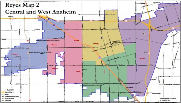
The “dog” is District 1, in the blueish tint. Here, it is facing east (or towards the right.) Most of the West Anaheim peninsular forms its body; it has a thin neck and a large head, with its ear flying backwards as it jumps towards the pink-tinted District 2. (If, once again ignoring the little details created by the Anaheim Island, District 2 looks like the torso of a guy with his right left up warding off the dog, then you’re visualizing it correctly.)
The problem with the “dog” shape is obvious: it connects two somewhat distant areas (West and Northwest Anaheim) through a narrow “neck” stretching a quarter mile from Magnolia to La Reina Streets — about half of the distance from Magnolia to Dale (which is much larger than La Reina.) That just happens to be where the border with Buena Park begins. Less obvious, perhaps, are the advantages of this approach: its proponents argue that the community north of La Palma between Brookhurst and Magnolia is more similar to those living west of Magnolia and north of Lincoln, on the Peninsula, than either are to other adjacent areas.
If you turn the block with the dot in it (representing the Brookhurst Community Center) pink, and then turn the top pink block blueish (so that District 1 actually touches Euclid St. and District 3), then you have created “the aardvark” (due to its long “nose.”) Pretty much any criticism of “the dog” also applies to “the “aardvark,” but with even greater force.
(If all of this strikes you as pretty picayune stuff — maybe even boring — that’s fine: you’re just probably not a mapmaker! Mapmakers know that this is exactly the sort of discussion about “communities of interest” that we’re supposed to be having as we near the end of the process. We enjoy this sort of fine-tuning — and it makes for a better map.)
The other argument for the “dog” approach is that it puts both sides of the Anaheim Island into the same district. This, frankly, strikes me as wrong-headed: the Anaheim Island is a barrier to the continuous flow of the city; it is not supposed to be transcended if there’s a good alternative option. Arguments have been made that there’s a common “community of interest” among those who live adjacent to the Anaheim Island — and I just don’t see that. A better argument is that the Muslim community has some landmarks across the Island — such as Magnolia High School, which draws much of its population from its east — but the trade-off here is whether keeping every bit of the Muslim community together in District 2 is justification for drawing a very long an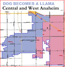 d non-compact District 1.
Politically, it probably makes sense for the Muslim community to have a strong representative in District 2 and a representative in District 1 who, due to the presence of Magnolia H.S., has to pay them at least some attention. Stuffing every possible Muslim-related site into one district limits their influence to that district. (Including the Brookhurst Community Center in the same District as most of the businesses, by contrast, does make sense.)
One solution is shown at the right: switch Census Block Group 44 (population 2,536, bounded by La Palma Ave., Crescent, Brookhurst, and Gilbert) with Census Block Group 35 (population 1,724 bounded by Crescent, Lincoln, Magnolia and Gilbert.) But that transfers a little too much population. My guess, from eyeballing it, is that transferring some or all of the northwest portion of Census Blog Group 44 — that bordered by La Palma Ave., Gilbert, Valdina, and Moraga — would restore the balance close to where it should be. You can picture that as coloring the top left quadrant of the square with the black dot in it returned to being blueish.
My prediction: some version of the “dog” map wins, sad to say. But if the dog turns into a llama, even a llama with a jowl, it’s not quite so bad.
(4) Should the Platinum Triangle be divided from the Resort District proper?
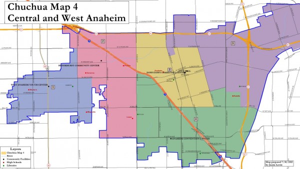
The main criticism offered by those favoring the Reyes map towads the Chuchua and Gagne maps is that the latter pair do not separate the Platinum Triangle from the Resort District west of State College. This is true: neither map separates them — because, as the original “Ponderosa Community Map” suggests, they’re both part of South Anaheim and South Anaheim is a cogent and coherent “community of interest.” The Chuchua 4 map, reproduced below shows the Ponderosa Map — created by residents of South Anaheim — as its southern district (in green).
The argument for dividing them is based on the theory that it gives the Council Member who represents the territory including Disney Resort, GardenWalk, the Convention Center, Angels Stadium, and the Honda Center too much power and responsibility. My first response is that those “landmarks” constitute as clear a “community of interest” as you’ll find — and they belong together. My second response, as I’ve repeated many times here, is that anyone who thinks that the burden and benefit of representing these entities will fall to just one Councilmember — or even necessarily to the Councilmember who represents this area — simply doesn’t understand the recent history of Anaheim politics. I am informed that the Angels have been hosting swanky fundraising parties for Councilmember Kris Murray in their luxury suites for some time now. That wouldn’t change even if she were officially limited to Anaheim Hills’s District 6. The Angels, Disney, etc. are going to aim to control everyone in every district, if they can.
My prediction: South Anaheim will be split to put the Platinum Triangle with East Anaheim, sad to say. But if it happens at a logical dividing point such as State College Blvd., it’s not quite so bad.
And one final question remains, which is what most of the remaining mapping will likely be about:
(5) What are the best majorities and margins for the 3 most Latino of the 6 districts?
The judges’ decisions of last night clarify what is the primary remaining issue at this point: given the three flatlands districts east of Euclid, how does one provide Latinos with the maximum ability to compete for Council districts — which was, the judges seem to understand very well, the point of the legal settlement with the City? All we know for sure is this: one of those districts must be over 50% Latino in its “CVAP” — Citizen Voting Age Population, or the potential pool of voters. (Note: some within this pool will be eliminated from it due to felony status, mental infirmity, etc. — but they still count within CVAP.) Everything else is negotiable.
This was what we covered back in installment 3 of this series. I’ll reprint the table from there

To the right of that rainbow of categories, each white column shows the percentage of Latino CVAP in the first- (magenta), second- (red), and third -(orange) most Latino districts. Each shaded column shows the distance between Latinos and the next-most highest (or higher) ethnic/racial group, which in all cases is Whites.
Let’s break out the three pairs of numbers that we’ll need, showing first the proportion and then the margin (in parentheses):
Reyes 2: 51 (18) . 47 (12) . 44 (6)
Chuchua 4: 55 (25) . 48 (11) . 39 (1)
Gagne: 54 (22) . 52 (18) . 37 (-2)
(The “-2” margin in the Gagne map reflects that in the third-best Latino district, Latinos do not have a plurality.)
One of these maps is clearly better than the others for Latinos — and it’s the Reyes 2 map. The Chuchua 4 map and the Gagne map pack too many Latinos into their top district — where they cannot be used to produce a third competitive district, as the Reyes map is able to do. And having three competitive districts is — as was demonstrated by yesterday’s crowd — what Latinos see is being in their interest. (And I agree with them.)
(As an aside: if I understood this, why did I produce such a deficient map here? Simple: I had already produced a map with “good” numbers — as good as Reyes 2 — with the first map Brian and I submitted, the Chuchua 2 map. In the Chuchua 4 map, I was stuck with using the Ponderosa map, which created that “39 (1)” district — meaning that the other two districts had to be more “packed” with Latinos than I would have preferred. Why did I stick with the Ponderosa map? Because the Chuchua map, while it would be a decent final map if chosen, is really designed for one primary purpose — as the alternative that would defeat the City Council’s map in court if the City Council tries to pull any shenanigans. That’s why its districts are so compact and obvious, why its deviations from perfect representation are so tiny, and why — where possible — it yielded to the expressed preferences of the people living in the area. Those are among the top criteria that judges would use in the event of a challenge; Chuchua 4 would squash any gerrymander that might come from the City Council. (In other words, Brian and I are playing a slightly different game than most other mapmakers are playing — looking not to the City Council but past the City Council.) However, in the light of the popular support expressed for the Reyes 2 map, the main author of the Ponderosa map said that he was comfortable with its depiction of the southern district, so I no longer feel bound to the original Ponderosa map and will revise my map accordingly. As ever, the judges may or may not grant me leave to amend!)
What would be the perfect numbers for a final map? Here’s my thinking, presuming that we have about 142% of Latino CVAP to distribute over the three eastern flatlands districts (or 143%, given the “fix” to District 6 that appears in Gagne’s map) and 36-37 points of “margin” to play with:
- A “best” district with 50.01% to 51% Latino CVAP and a margin of around 17 to 20.
- A “second best” district with 46% to 49% Latino CVAP and a margin of around 9 to 12 (so that the combined margins of the two best districts totals to 29%).
- A “third best” district with 43% to 46% (plus 1% if the Gagne fix works) and a margin of 7% to 8%.
That’s about the best you can do. (I hope to do it myself!) I expect that Gagne will also be polishing her map a bit and would not be surprised in Reyes, addressing some of the criticisms presented last night (amidst a wave of accolades), did so as well.
If this worrying about the racial margin of Latinos over Whites strikes you as unseemly, recall that that is what the districting process, emanating from a legal settlement between the City and the (Dr. Jose F.) Moreno plaintiffs supported by OCCORD, was intended to do. It was intended to remediate a long history of Latinos not getting a reasonable proportion of representation in Anaheim, and to prepare Anaheim for its Latino-CVAP majority future. That’s not the judges’ decision to make — and, unless they want a lawsuit with one hell of a lot more firepower than CATER can muster, not the City’s option to override.
And there’s just one thing that we must keep in mind: Even with the best designed map, it may not work.
Because the City’s Council elections are “first past the post,” with no runoffs, it is possible for those opposed to Latino representation to run a whole bunch of Latino candidates to dilute the vote. (Think of the “Jenny Rivera” candidacies of years gone by, or the JoJo Moreno (aka “Joe Moreno,” aka “Jose ‘Joe’ Moreno,” aka “Jose Moreno (2)”) challenges to dilute the vote for Dr. Jose F. Moreno last year.) If JoJo Moreno takes 9% of the vote away from Jose Moreno in a race between the two of them and one White candidate, then an 8% Latino CVAP advantage in a district turns into a 1% deficit. Of course, that wouldn’t happen — they would run both “non-Dr. Jose Moreno” and another “Jenny Rivera,” or even find people named “Carlos Santana,” “Ruben Blades,” “Chris Montez,” “Trini Lopez” (for the older set), and someone willing to change their last name to “Ozomatli” to all run against Dr. Moreno at the same time. Then, with only a single anointed white candidate such as Gail Eastman in opposition, she would likely win. And, of course, the same could happen in other districts as well.
(How could one beat this sort of diseased evil perfidy? Organize. There’s simply no second option.)
Nor would it be surprising to see “fake” Latino candidates arise — such as when Steve Lodge reappeared on the Anaheim political scene in 2012 as “Steven Albert Chavez Lodge” — a name no one that could recall him using prior to the election. He is rumored to be on his way back from the Inland Empire for another swing at the election; no word yet on whether he’s now using the first name “Esteban.” (Or, for that matter, “Cuauhtémoc.”)
All a map can do is give Latino candidates a chance to be competitive; the rest is up to the voters. That’s all that we can ask from the judges on the Committee — and it looks like we will receive it. If and when we do, it will then become all that we can ask from the City Council. But at least, as of last night, we are off to a good start.
The candidate formerly known as Steven Albert Chavez Lodge will dispense with names altogether and campaign under the symbol of a winged serpent, for maximum authenticity. Or something.
Ok, I’d pay to see that.
None of this matters. Disney will buy their districts, the unions will take a few, the “activists” will corner one.
The taxpayers lose. The corporations, illegal immigrants, gang members and welfare moms WIN.
The guy who works, pays and plays by the rules lose out.
This is a quinsential power/money grab.
Are you a happy individual?
Actually, the guy makes a lot of sense. However, it’s not a “grab” yet, it’s still terra incognita for all concerned. A year from now there will be a lot of grabbing going on. The Kleptocracy will have to change its tactics and the unions may get to a slice of the acttion if they don’t screw it up (think John Leos).
The “guy who works and plays by the rules” will likely lose out. Still, it’s the only shot we have of breaking the monopoly.
Your last sentence ditto. This bitter dude doesn’t see that, I think he goes through his whole life thinking everyone’s swindling him.
Possibly a hasty judgment on my part.
It’s either that or … why get up and blog?
Nicely said Vern. You may have listened to Victor’s ” Yo no canto por cantar, ni por tener buena voz”
Expecting the average Joe will lose out is like betting on red at the roulette table.
See I get tired of that nihilistic attitude from Dave and Nip… we do what we do here because we think we can wake up the average Joe and make him look after his own interests. It’s either that or … why get up and blog?
No way, man. The odds are not that good.
There are days, Vern. There are days.
But, I agree with you. If for nothing but self respect, someone has to say “Enough”.
I’ve been saying “enough” for 25 years. I think I’ve earned a little jaundice.
Fine, jaundice earned.
*Dr. D., we are a bit confused here. You mention Newport Beach as one of the impacted cities due to the Anaheim District Election concept. New News….we have had Districts in Newport Beach since……well before we were born for sure! Goat Hill (Loving known as Costa Mesa however should be impacted because of their substantial Latino(a) populations which are centrally located in West Costa Mesa mostly. Fullerton for sure needs to District Up – so that should only take 20 more years…..(They are so well known for their quick responses to sensitive situations – as everyone is aware!).
*To clarify a bit: Newport Beach is a Charter City and ever since 1906 had created District Representation, however – all citizens within the city can vote for each district Representative. Our belief is that all cities should be required to establish Districts. This assures, that whoever is elected to represent each district is primarily responsible to their own constituents. Our main problem has been the baton passing of the Mayoral spot. Mayors need to be elected, not selected by the folks with the most votes on City Council. We have been calling for any elected District Representative to be able to run for Mayor – for a term that does not exceed his own elected District term. Up to four years! Meanwhile, in any city election cycle – any citizen could challenge by filing for the Mayor spot – on the General Ballot.
Confusing? Not so much, it all starts with establishing those pesky districts. The key is not falling into the LA system where only people from a certain district can vote in one district. They should be able to vote for anyone governing their whole city. We invite the folks in Anaheim to study the Newport Beach model and make any necessary adjustments to fit their issues and situation.
We all know you and Santa Ana have the “dog food districts” system. That is not what Anaheim fought HARD for.
Read, grasshoppers…
http://www.orangejuiceblog.com/2013/06/sirloin-or-dog-food-council-prepares-to-foist-santa-ana-style-faux-districting-on-anaheim-tonight/
That was a great post of yours, Vern. Beating the stuffing out of the “dog food” plan was a real pleasure. Good times — and of course the good times are not yet over!
I stand by Vern’s response. Let’s make this easy on you: let’s say that the world will be governed by a panel of 23 people, each representing about 316,000,000 people. Each one of those people has to come from one of the world’s 23 “equal population districts.” The United States is one of them.
Would you prefer that the choice of representative for the district consisting of the the U.S. be voted on by people within our district — or voted on by everyone else in the world without regard to what we think?
P.S. I am not advocating world government here, just throwing you off your game!
P.P.S. But if it does happen — vote for me for District Representative! I’ll go a great job of representing the needs of the Chinese, Indian, Indonesian, Brazilian, and Bangladeshi voting majority. And everyone else can go such eggs.
P.P.P.S. I wouldn’t really do that. But someone in our area would, if the whole world could vote on who represents the USA. That’s just like what happens when who will represent each given ward in Santa Ana is voted upon mostly by people outside of that ward. You Newporters and the Santanans should change that!
*Dr. D., “Limits and boundaries” come to mind. We love these “analogy wars”. No we don’t want the people of Baja voting for the Mayor of San Diego. No we don’t want the President of Mexico voting for Governor of California. You scribe the limits of your city or township. You divide it equitably, You then have all the citizens of that city or township for the five or seven best choices. One choice for each District of your city or township. But then if you only want to vote for your next door neighbor…..that’s cool, You shouldn’t have any limits on who you can vote for…..that’s why they have write-in candidates.
I get your defensiveness. I just think you be better served (as would they)by informing the public at large in under one million words and without the childish editorial. But, I guess thats the kind of people you draw. Not exactly made for a wide audience!. I especially liked the reference to pehaps the richest and poorest city in the county as DogFood.
Dogfood is shorthand for a good story I wrote a couple years ago, contrasting “at large” district elections vs real district elections as “Sirloin vs. Dog Food.” You should read that story, which is linked somewhere above, I don’t have time to look today.
There was really not much there to provoke defensiveness. You’re a nihilist and also somewhat bigoted. We get unfamiliar people like that commenting here a lot. Your opinions are duly noted.
My guess is that either you’re someone unfamiliar with this blog who has just wandered in and decided to opine on its level of verbosity, maturity, and potential reach, prior to a profound misunderstanding of what Vern wrote … or, you’re someone already familiar with the blog who has an ax to grind. Given the wild but nasty swipe that you took at Vern, I suspect that it’s the latter.
P.S. Vern undersells his effort. It was a *very* good story.
Congratulations! The Chuchua 4 map was one the selected maps.
OCREGISTER: Three voting maps advance for consideration
http://www.ocregister.com/articles/city-680352-maps-voting.html
I’m going to try to get them to substitute one in, given that the Chuchua 4 map was written to accommodate the expressed preferences of the Ponderosa Community for the Southern (usually designated “District 4”) district. I’d now probably prefer Chuchua 6 or Chuchua 9. (Of course, I’m not done with Chuchua 9.) They may say no — in which event Reyes 2 would be pretty good, though I think that it could be improved a bit.