.
.
.
Prepare to meet your Mapper!
[Author’s Note: if you want to jump down to what map Brian and I actually favor, it’s down in Part 4C!]
[UPDATE: Here’s a table of the final maps that were under consideration, with all four flavors of the Chuchua maps that had been favored at various times.]
1. Introduction to the Conclusion
At the end of the process, last Tuesday at Loara High School, it wasn’t even close.
The five retired OC Superior Court judges on Anaheim’s Redistricting Commission (formally known as the “Advisory Commission on Electoral Districts,” or “ACED”) decided to send only one map to the City Council as its recommendation. The Reyes 2 Map — which had been favored by a coalition of activist groups from the moment it was introduced — will be accompanied by an official report that has now been completed and and submitted and will be voted upon on Wednesday Sept. 16.
As one of the two authors of rejected “semi-finalist” maps — I’m fine with that result. It was far from obvious at the outset that this Committee would produce such a sound result. That they did so is a testament to the good work of the five judges on the Committee, who made sound choices (even if not always what I’ve thought were optimal ones) throughout. It has been a pleasure — not only to the observers, I’m guessing, but also to the judges themselves — to see them come together to work as a panel.
A. The Judges
Starting from the outside of where they sit, Judge James Jackman (at audience left) and Judge Thomas Thrasher (at audience right) have had opposite reactions towards what I suspect will be the main line of attack on the Reyes 2 Map that I suspect any opponents will raise. Judge Thrasher was extremely responsive to, and clearly moved by, the consistently strong and coherent participation by the coalition comprised by OCCORD, OCCCO, and other groups that came out every time and spoke forcefully and often in the appropriate level of detail about their support for Reyes 2. At the other end of the panel, Judge Jackman was consistently unmoved the the audience;s display of support — not in any bad way at all, but because he clearly believed that the judges had to disregard the “gallery” (as they would have to do in court) and judge the case before them on the merits.
When Judge Jackman and Judge Thrasher came down in the exact same place at the end — even though it was not exactly what I had wanted — it testified to the finding that Reyes 2 did not prevail simply because it had popular support from activists, but because it was able to fend off all criticisms and to attract a broad range of Anaheim political figures in its support. Judge Nancy Wieben Stock took the “writing hand” in presenting what amounted to an opinion for the panel last week, and it was well-considered. I felt like, in my treatment by the judges, I had had “my day in court” (even though I had some other problems with the process, which are addressed below.) Judge Stephen Sundvold was consistently asking probing and perspicacious questions, his thinking clearly consonant with that of Judge Stock throughout.
I had at one point in August aggressively criticized Committee Chair Justice Edward Wallin in print here based on views about the process that he had stated in early June. This criticism turned out to be so unfair based on his evolved views, so out of date, that I took the rare step of deleting the post after only a couple views. (The judges, though, did receive it in a packet I provided to them — to their credit, none of them tried to beat me up in the parking lot after a meeting.) I can no longer receive any favorable treatment from ACED, nor do I expect to see any of them on the bench when I come to court, so I hope readers will accept that what follows is heartfelt: Justice Wallin — the sole Anaheimer on ACED — has done an excellent job of leading this committee. His main accomplishment, as the judge who spoke out most clearly over the course of the process, is that he was willing to change his mind in response to new testimony and evidence.
There was never any doubt as to whether Justice Wallin’s heart was in the right place — he strongly wanted to fulfill the terms of a settlement that required that lines be drawn to remove some of the barriers that Latinos have faced thus far in seeking representation. The question was: how does one best do so? Over the course of weeks and months he moved from a position in favor what was in effect “packing” — cramming enough Latinos into one or two districts that they’d be certain (more or less) to elect one or more Latinos to the Council — to a position that the necessary effect of “packing” was unacceptable. “Packing” would mean that Latinos would necessarily be in the minority in four out of the six districts, despite that Anaheim’s population is heavily Latino. Wallin was willing to take the risk that, by not creating one district with a 30-point Latino advantage, it is possible (although not that likely based on any factor that the judges can control) that no Latino will prevail in any of the three likely districts where Latinos are likely to be competitive. If that were to happen, I don’t think that anyone would be sadder at the result than him, in part because he would be a target of criticism by those who hadn’t followed the process — but he was willing to listen to experts who argued that “a fighting chance” in three districts was the best was to go. That took courage as well as a great mind and a good heart.
B. The Reyes 2 Map — and the Others
I’d change a few things about the Reyes 2 Map, but its deficiencies aren’t too serious. Its main deficiency is that — ironically, given that it was pushed through by an uncompromising coalition of largely Latino groups — it doesn’t favor Latino interests as much or as well as it could. (More on that below.) But, by and large, it’s a solid effort and — very importantly — for the most part it “looks right.” Relatively few residents will find their home spot on the map, look at their district and those around it, and complain “I don’t belong there!”
I’ve had plenty of arguments over the past few months as to whether the City Council will accept the result of the judges’ efforts (as it really should) or try to change them. Almost to a person, other observers have said that they would have to go along with the committee recommendation. Brian Chuchua and I have consistently been telling them: “you don’t know these people! They won’t necessarily be held back by public opinion!” We think that the Council is fairly likely to try to change the maps — which is why we came up with maps that would provide a good challenge to the existing maps in court. I’ve made no secret of the fact that that is why I’ve put so much time into the process: to make it harder for the Council to pull any shenanigans.
As I’ll discuss below, one Council member is especially likely to want to reject the Reyes 2 Map: South Anaheim’s Lucille Kring, whom it places in a district with a 12% Latino advantage over whites. (Her fellow member of the Council majority Jordan Brandman could probably handle that sort of district. Kring, though, has not done much to endear herself to Latinos during her term.) Kring’s best bet would be to fight the Reyes 2 map with one of the other semi-finalists. For reasons that I’ll explain below, the map from Benita Gagne is probably not a good vehicle for that. The Chuchua map might be.
But which Chuchua map? We’ve submitted ten of them, adjusting to new information about judges’ preferences and sometimes adopting others’ contributions!
Chuchua Map 4, the one most favorable to Councilwoman Kring — which puts her in a district with less than a 2% Latino plurality — is not the one that we eventually favored. We asked the Committee to substitute in Chuchua 9 as a semi-finalist and they seemed to say “yes” — it’s the one that highlights what we see as the two most serious deficiencies of the Reyes 2 map. (It’s a little better for Kring as well, putting her into a district with only a 9% Latino advantage, which might be about comparable to the benefits that she gets from incumbency and the fanatical support of the police union. In other words: it makes for a pretty fair fight.) Now the question is, is it “still in the mix” (as much as the Gagne map is), or is Chuchua 4 — a map that we submitted based on expressed local preferences that changed over the course of the process — the one that will be considered to be a “runner-up”?
This means that I’m going to have to talk a lot more below (way below) about the series of Chuchua maps than I planned to — or that I wanted to at this stage. It turns out that which map finished a distant second or third could end up to be kind of important. But first, let’s talk about the winner!
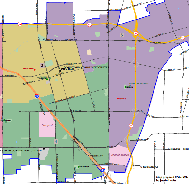
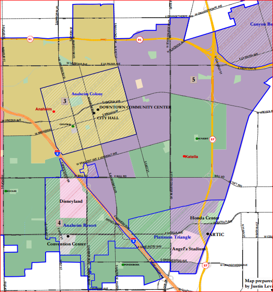
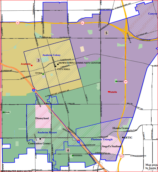
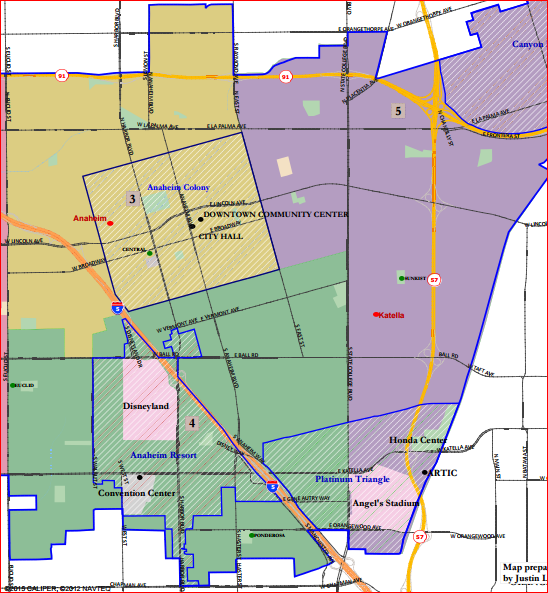
2. Getting to Know “Reyes 2,” Your Victorious Map
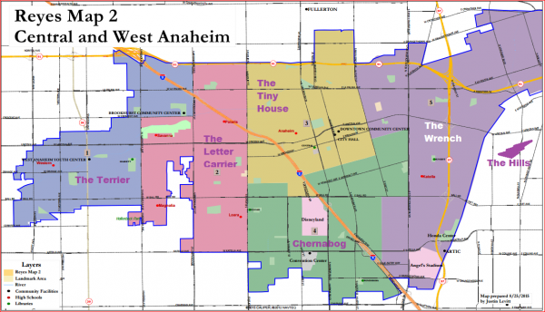
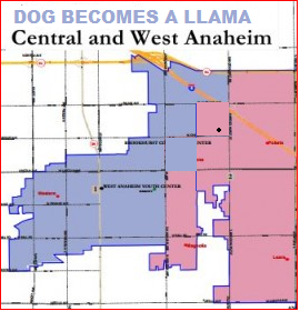
As this is likely to be our final chosen map, it’s time for people to get a sense of it. (As usual, Anaheim Hills — for these purposes, most of “District 6” — is not on the map because its borders have largely been settled.) I’ve taken the liberty of naming the other five districts for the same reason that the ancients named the constellations in the night sky: superimposing a mental image onto an object is a great is a great way to help you remember its shape.

Chernabog, best known from Fantasia’s “Night on Witch Mountain,” though recently invoked for Disney’s “Once Upon a Time” as well.
West of Euclid Avenue, Reyes 2 (now technically “Map 3,” soon to be “the Map” — but to we who have followed the process it will always be “Reyes 2” in our hearts) divides the territory into two districts. District 1, to the west and northwest in indigo, looks like a terrier in to prospect of attacking District 2, in pink, which looks like the torso of a letter carrier raising a right knee for protection. (“The Terrier” attacking “The Letter Carrier”: You cannot unsee what I have just made you see!) Technically, District 1 contains “Northwest Anaheim” and District 2 “Southwest Anaheim,” but I suspect that people will begin to use the terns “West Anaheim” and “West Central Anaheim” (or maybe “Near West”) to describe the districts.

If you don’t like Disney’s district being named after its most evil villain evah, we can offer you a nice Camazotz instead!
To the east of the north border of Euclid is District 3, in gold, which is almost as close as one can get to being square given the tilt of the Colony District. I call it “The Tiny House.” (See, it has a little chimney at the top and a little walkway to its front door at the bottom. Cute!) Below it is a district that isn’t shaped like much of anything — but given that it seems to spread out its wings on both sides of Disneyland, which serves as its hunched head, I decided to name it “Chernabog,” after the Evil Demon from Fantasia‘s “Night on Witch Mountain.” (This is no commentary on Disney, but just giving it propers for its beloved, and be-hated, classic character. If Disney objects, one could go with the Mayan bat-god of Death “Camazotz,” upon whom Chernabog was largely modeled.) District 3 is essentially “North Central Anaheim” and District 4 is “South Central Anaheim.” “Central” may end up be dropped from both of them, I expect, at a little cost in accuracy.
Wrench-head-shaped District 5, in purple, lies between the two Central Districts and Anaheim Hills. “The Wrench” encompasses both Northeast and Southeast Anaheim, and would probably just be called “East Anaheim.” What brings most of its populated sections together is proximity to the 57, which fared a lot better than the 5 (which runs through all five flatland districts) as a means of tying together at least one district in the city. District 6, Anaheim Hills, requires no constellation name to help you remember its shape: it’s just “The Hills.”
3. The Gagne Map and the “Third-Best Latino District” Principle
Describing Benita Gagne’s map is easy. Describing the Chuchua Map, which I designed with lots of smart expert advice from Brian (and a few others, none on Council or related to anyone on Council), is (for reasons to be explained) hard.
The Gagne map was a revision of Consultant Map 1, the work of ACED’s paid consultant, San Diego’s Justin Levitt. Districts 1 and 2 were the same in both. Gagne made District 3 a bit more clean and compact and pulled District 4 a bit southward to more properly make it into a “South Anaheim” district. These changes simplifying Districts 3 and 4 made District 5 look more complicated and jagged as it dipped towards the southwest between them — but that wasn’t the problem with it. The problem with it, from the ACED judges’ perspective, was that it created two very good districts for Latinos at the expense of creating four minority districts from Latinos, which ranged from “not very good” to “extremely bad.”
The judges — rightly, in my opinion and that of most (though not all) of the Latino activists involved — believed that creating four Latino minority districts out of six did not pass the “good optics” test for districts that were, after all, being drawn to pursue the settlement of a lawsuit over Latino voting rights. Anaheim could easily support one Latino majority and two strong to middling Latino plurality districts — and, if it could, then it should. This is not “cheating in favor of Latinos” as some would have it; it’s given a group that has historically been massively underrepresented in Anaheim a fair shot at coming near to representation by a Council proportionate to its fraction of the voting pool. The Gagne map was not wrong (and certainly not ill-inentioned) in its conception — but after much deliberation the judges determined that it was not the best way to assure a fair voice for Latinos in Anaheim. While Gagne has argued persuasively that the choice between a “2 Latino Majority and 4 Latino Minority” map and a “1 Latino Majority, 2 Latino Plurality, and 3 Latino Minority” map is a political one best left to the Council, this decision actually goes to the heart of the remedy sought in the OCCORD lawsuit and so it is the prime example of what should not be left to the Council! The judges have considered the question and made their firm recommendation. Implicit is that recommendation is that the strength of the third-best district for Latinos is key.
4. The Many, Many, Chuchua Map(s) and Why They Existed
That brings us to the Chuchua map — or, I should say, “maps,” plural. Their submission was bit of a mess, I’m afraid, given the continual revisions — even though its final result was, I believe, closest to what the Latino activists and the judges had said that they wanted.
I submitted ten versions of the Chuchua map by this time I was done, pretty much for the same reason that the Consultant submitted four: I wanted to show the judges what could be done if they made different choices about their priorities. The first one to get all the way to submission was “Chuchua 2v3 (“2, version 3”); when the Ponderosa community came out with its own map of what South Anaheim looked like, I grafted it into Chuchua 2v3, moved things around, and submitted Chuchua Map 4. Chuchua Map 4 is what made it to the final trio, despite that I had presented four options for changing it in the third-to-last meeting and two more for changing it last Tuesday night. Neither Chuchua Maps 5-8 nor Chuchua Maps 9-10 made it to the judges in time for consideration. (Map 10, which I think would have ended up being the best, could not even be properly finished before the meeting began in time to optimize it.) I think that by the end I think that I successfully shoved Map 9 into place as Brian and my final choice to represent “our team” instead of the barely Latino District 4 plurality in Map 4.
Why all of the delays in submission that impeded consideration of the revisions after Chuchua 4? Funny story, that — one that I think is worth telling.
A. A Problem With Process
This section speaks to a deficiency in the process — one that should be remedied before the next districting takes place in 2021 and that the state of California generally might want to think about alleviating, as more cities engage in districting and redistricting. Simply put: We need to give the public better software if they’re going to be able to contribute effectively.
Because I did not have a “GIS” program of the sort that was publicly available to residents of California in 2011, I was unable to do three important things in real time.
- When I changed my assignments in the spreadsheet, I was not able to see a graphic representation of them. (It was very easy to make mistakes in the process, which is why “Chuchua 2v3” was my fourth — or fifth? — attempt at getting my maps contiguous.)
- Much of the way to solve problems was not to use the “Census Blog Groups” (aka “Population Units”) one could manipulate in the spreadsheet as given, but instead to divide up an occasional Population Unit and put some of it into one district and some into another. Unlike the Consultant — and (I believe) unlike Reyes (whose map had help from elsewhere) and LULAC (whose map was a joint project with MALDEF), I had no way to make those assignments in my maps — or to even figure out where a Population Unit could be split! So I had to either work directly with the Consultant when he was available — and client calls were continually preventing me from getting to meetings an hour ahead, when he was there — or else wait for him to send me maps showing how individual Population Units could be divided. Because he was at an academic conference between the last two meetings, I lost the opportunity to get my final revisions to the judges while they might still be considered.
- I also had no way to calculate the statistics — not only raw population, but also Latino and White CVAP (among others) — that would accompany any maps I submitted. I had to wait for results to come from the Consultant, who was understandably busy with other things. Because optimizing these statistics was a critical part of the process, that prevented me from turning in revisions when they could be most useful.
Because I couldn’t make revisions, I was stuck with Chuchua Map 4 — which had a southern district that I did not think was particularly good. (This was the “Ponderosa Community” map, which was the only statement we had available of the preferences of residents living in the south.) And then, at the very meeting at which Chuchua Map 4 was introduced, the representative of the Ponderosa Community who had drawn the map came up and said (reasonably enough) that he had changed his mind! That meant that Brian and I no longer had to be stuck with his proposed District 4, which gave a relatively pitiful two-point plurality to Latinos when getting a six-point edge was readily achievable and even a nine-point edge could be achieved with some effort, even in what would be the third-best district for Latinos.
B. Evolution of a Map
Chuchua Map 2v3 (above left) — overall, a very good map — showed the problem with not being able to divide a Population Unit. Do you see that the “gold-colored” district, rather than being squared off, seems to have a grown in its southeastern end? Here was the problem: we wanted to keep the Colony unified, but the portion of the Colony northwest of South and East streets was stuck in a population unit that extended far beyond the Colony. If I wanted to keep the Colony whole, the result was an odd appendage extending into District 5 (in purple), with an additional wart sticking out because Bond Street doesn’t extend from South Street to Diana Avenue (which was in the same district as the lonely corner of the Colony), below which it turns into Lime, causing the block to jut out until it hits Wayside Street.
(Have I mentioned that I now know far more about Anaheim geography than I ever wanted or expected to?)
This problem was fixed in Chuchua Map 4 (above right), which allowed the portion of the Colony orphaned in the Population Unit to be lopped off and merged with its own kind. But the southern District 4 had been drawn, unfortunately, during the short period in which the “Ponderosa Map” was presented as the preference of the Ponderosa neighborhood. (We were all learning as we went along!) As drawn, it was on the verge of not being a plurality Latino district, which left its third-best Latino district as only slightly better — three to four points better — than that of the Gagne Map.
Chuchua Map 5 (above left) — was an attempt to satisfy the tentative preferences of some judges for map that created two majority Latino districts, but without dividing the Resort District from the Platinum Triangle. The green district was very close to that of the Gagne map. Brian and I, like the Latino activists, did not want a map with four Latino minority districts — so we did not favor it. Chuchua Map 6 (above right) — gave up the desire to keep the Resort District together with the Platinum Triangle — instead holding onto the desire to have one Latino majority and two decent Latino plurality districts. This led to a reasonably compact map with good numbers — but not as good as we thought we could get with more refinement.
Chuchua Map 7, above, was a good-faith experiment that failed in a very useful way. I did my best to draw a good map that had split the city at Euclid, had two 50% Latino majority districts, and continued to separate the Resort District from the Platinum Triangle (in my case, along State College.) My best effort, as you can see, was still extremely ugly — highlighting the process of looking for white-plurality areas to color green and Latino-plurality areas to color purple. If the judges had any doubts about abandoning at least one of these criteria, one look at this map should have cured them. (Maybe it did!)
That leaves Chuchua Maps 9 and 10 — at pages 92 to 98 of Attachment C of the City’s agenda packet. (Warning: this is a big and unwieldy PDF file.)
Chuchua Map 9 (above left) attempted to improve incrementally on the “third-best Latino district” of Chuchua 6, moving it from a 6% to a 7% advantage. This was also an attempt to keep the “total deviation” between the districts as low as possible while adhering to the other criteria: it got down to .85%, which — if you care about such things, as I seem to do more than anyone else around — is excellent. Chuchua Map 10 (above left) was intended to see what would happen if I relaxed that total deviation criteria a bit — roughly allowing it to get up to 1.9% — in order to get a more visually and conceptually compelling carving. As you can see, the east side turned out quite well: While extending South Street all of the way to State College, District 5 — the third-best district for Latinos — has a 9% plurality! The problem is that area west of I-5. District 3 in the north is left with 50% — which makes transferring territory to and from it a delicate proposition, because it cannot drop below 50% (+ 1 resident). District 3 has a 16% plurality; District 4, the second-best Latino district, has an 11% plurality. Finding exactly where to split the population units so as to retain a bare majority in District 3 while keeping the overall deviation under 2% or so would likely have taken a few more hours, because of the restriction against dividing “Census Blocks” themselves. Without access to the software that the Consultant had, I didn’t have time to make it look really neat and intuitive. (Maybe it couldn’t be done at all!)
For that reason, when the judges asked me to pick only one map to substitute for Chuchua Map 4, I chose Chuchua Map 9. Chuchua 6 had its appeal, as did Chuchua 10 — but Chuchua 10 would have taken too much time to perfect.
C. Why Chuchua 9 Should Be Preferred to Reyes 2
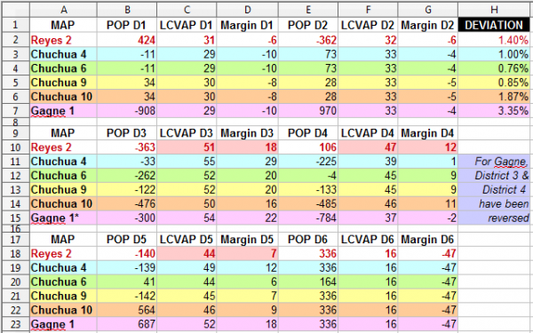
The Latino pluralities in Reyes 2 are 18% for District 3, 12% for District 4, and 6% for District 5. The Latino pluralities in Chuchua 9 are 20% for District 3, 9% for District 4, and 7% for District 5. (As noted above, Chuchua 10, if completed, would beat both of them: Its current District 3, 4, and 5 pluralities would be 16%, 11%, and 9%.) So, given that that’s pretty close, what is the problem we have with Reyes 2?
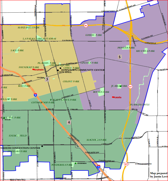
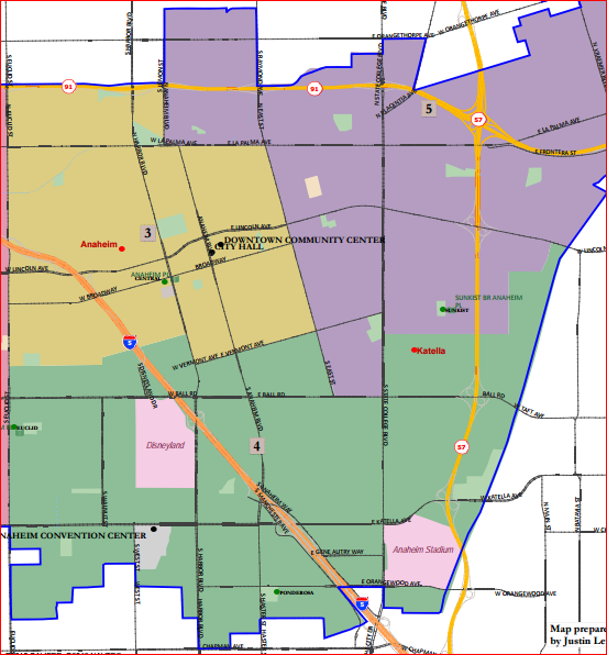
It comes down to this: Lewis St. vs. State College Blvd. Reyes 2 divides District 4 from District 5, south of Ball Rd., at Lewis St. Chuchua 6, 9, and 10 divide them at State College. That area between Lewis, Ball,, State College and Orangewood has another name: it’s the western portion of the Platinum Triangle. (Technically, the “Platinum Triangle” proper is south of the Union Pacific tracks — which cross State College south of Cerritos Ave.)
The reason that this matters is that a lot of new housing — largely expensive high-rises that will probably be disproportionately non-Latino — will be built west of State College between Ball, Lewis, and Orangewood over the next few years. Keeping this currently depopulated, mostly commercial, area out of District 4 keeps it from becoming MUCH less non-Latino — and therefore secures a likely Latino advantage in District 4.
In so doing, it makes it likely that District 5 — the third-best district under Reyes — will NOT be a Latino-plurality district at all. District 4 under Reyes has a 12% Latino plurality; it can “take the hit” from the Platinum Triangle construction. District 5 has only a 6% plurality — and now it will have the western Platinum Triangle added to it. When that’s completed, its third-best district may end up looking more like that of Chuchua 4 — or even like that of Gagne.
That’s my big problem with Reyes 2. It doesn’t protect Latino voting power as well as it could!
Chuchua 9, by contrast, moves the western Platinum Triangle into District 4, in which Latinos begin with a 9% plurality advantage. In Chuchua 10, that plurality advantage would start at 11%. These districts could absorb the new population without turning into Latino minorities — as District 5 might do under Reyes 2 once the western Platinum Triangle is developed.
Now there is a very good counterargument to this analysis on the merits: that it just doesn’t matter. This is because the Latino populations in these districts have been growing since 2011 — and will continue to grow through 2020. So even if District 5 swings 6 points towards white voters after the western Platinum Triangle gets filled in, we might expect the Latino population to have grown enough to counteract 3-4% of that growth.
There’s also a counterargument in terms of political logistics: Reyes 2 was obviously the product of lots of negotiation on the part of multiple interest groups, requiring them all to buy in. The coalition favoring it could not turn on a dime and support a Chuchua map even if its leaders wanted to. (By contrast, the Chuchua map is agile and easily amended — all it needs is for two people, Brian and I, to agree on a change.) I respect that the supporters of the Reyes Map couldn’t jump to the Chuchua map even if they agree with my analysis above! (I’m not saying that they didn’t hurt my feelings at times, but most of those were critiques of Chuchua Map 4, which deserved it.)
I think that recommending Reyes 2, but presenting Chuchua Map 9 (or 10) as a most favored alternative, would have been the best choice for the judges. (Benita Gagne feels the same about her map, by the way!) But I’m not going to fight that battle on Wednesday night. If Reyes 2 supporters are truly ambivalent among the competitors to their maps, then there’s no reason for them to weigh in. If they prefer one of the Chuchua maps, they can say so. The advantage of the Chuchua map as an alternate is that it lets the Council decide whether the Western Platinum Triangle belongs in District 4 or District 5 — and that is the level of political decision that I think it is fine to leave to the Council.
Oh, and one more thing, this time in the west:
THIS — from the Chuchua 9 & 10 maps — is better than the “terrier attacking the letter carrier” plan in Reyes 2. It keeps Little Arabia together — and it doesn’t look like two different populations are being connected by a thin-necked barbell. (But I still like the Gagne or Chuchua 4 maps for the West better than either.)
5. The Report
What the judges of ACED will really be voting on Wednesday night is adopting the Consultant’s report. You can read it here. It’s a 16-page PDF. By and large, I think that it’s well done. My only reservation is that the “money section” of the report isn’t as strong as it could be — strong enough to dissuade the Council from mucking around with it too much. Take a look.
Summary of Recommendation to City Council: The Committee is pleased to unanimously recommend the attached Committee Recommended Plan (hereinafter “Plan”, which, during the Committee’s deliberations was referred to as “Map 3” or “Reyes 2, rev. Aug 29”)) described in this report to the City Council of the City of Anaheim for its consideration. The Plan consists of two maps, one of the entire City and one showing only the central and western part of the City for ease of reference, as well as a demographic summary page. The districts are numbered one through six, with Council District 1 being the westernmost district and Council District 6 being the easternmost.
The Plan that we are forwarding to the City Council has received the overwhelming support of residents who testified from throughout the City at our 10 public meetings held in various locations in the City. More importantly, it received the most cogent and detailed testimony concerning how it met the legal criteria that guide our deliberations.
As retired Judges, we have spent our careers hearing cases in which we hear evidence and apply the law to the facts utilizing our own experiences, observations 2 and judgment. We have done this in this case and have concluded that this Plan does in fact best meet the legal criteria and best reflect the communities of interest within the City of Anaheim. In undertaking these deliberations we were also provided legal counsel and advice on the several maps that we reviewed during our deliberations.
The Plan has a total population deviation of 1.40%, with all deviation justified to follow major roads and keep communities of interest intact. It is a contiguous plan that strongly considers compactness, particularly in light of the elongated shape of the city. As the Plan description below details, it carefully delineates communities of interest as articulated in testimony during our public meetings. The Plan utilizes natural and man-made boundaries that are logical and easy to follow. This Plan carefully addresses voting rights. Significant and substantial public testimony supported how this Plan gives minority groups, particularly the large Latino population, the opportunity to elect candidates of their choice (this is also discussed below in more detail). Finally, we heard a substantial amount of support for this Plan from many individuals and groups from throughout the city, including support from those that had submitted “competing” maps, including maps that were in the final grouping of maps considered by the Committee (i.e., supporters of Map 1 and Map 2 before the Committee).
I think that that’s all good. But I think it can be great. Focusing on the importance of the “third-best Latino district” — the district that either allows Latinos to be the de jure or de facto minority in four districts out of six or else prevents it — is worth doing explicitly and with emphasis. If the Council were to ignore the value of anything that the Committee has done, this would be it.
I’ve seen the Committee’s judges struggle with understanding this issue, especially over the past month, moving from a relatively simplistic understanding of how to advance Latino voting rights to a sophisticated one. Council members, we must presume, may themselves be starting from “square one” when it comes to understanding this delicate issue. And, we must presume, they may approach it from a less impartial, less sophisticated, and less deliberative perspective than did this panel of judges.
This City Council needs and deserves the benefits of the judges’ deliberations, with much more than the relative gloss provided in the report. The judges have worked hard enough and well enough to provide a considered and detailed opinion for the record. I hope that they will recognize, Wednesday night, how very important it is that they do provide one.
Would the council accept a Chuchua map, even if the judges had decided to send it as the recommended one?
Don’t know. Not my problem!
As I say, at this point I’d think that they would accept the Reyes map rather than any alternative. But if they decide that what they really want is the “worst third-best Latino district” — whether Gagne, Chuchua 4, or something else — I think that they’ll get a quick and unhappy trip to court.
All that new housing on both sides of Katella between Lewis and State College is/will be mostly non-Latino, I would guess, but it will also house younger, non-political and non-registered and non-voting people.
The population is going swell significantly in the next three years and that should be considered, somehow, when drawing the district lines.
It can’t be used; districting must be done based on the 2010 Census figures. That’s probably a good thing, given how much an unscrupulous City Staff + Bare Council Majority (not mentioning any names here!) could game projections of population growth in various areas just for this purpose.
Did you see Oscar did a post on Chumley’s blog? What a punk!
Bad venue, but I complimented him.
Wait… maybe I shoulda read this piece first? I hope I didn’t give undeserved compliments.
Don’t worry, Vern; your praise was well-placed. Especially after learning (through reading his story) of Oscar’s ties to Anaheim’s good guys like Ryan Ruelas and Al Jabbar, I’m happy for the accomplishment of him and his supporters.
As I said yesterday — both at Los Amigos and in the Council Chambers — I hope that the Council does accept the Committee’s Recommended Plan, which Oscar submitted. I believed that I could improve upon it, and I think that I did, but regardless of that it is still a really good map. His advocates assembled a great coalition to support the “Reyes 2” map. I think that the differences between Reyes Map 2 and Chuchua Maps 6, 9, and 10 were relatively slight. Given that the community did make its choice, it was not just reasonable but right for the judges to prefer it. If they must consider any alternatives, I think that any changes they make should be solely where his map and my maps differ — but at this point I’d rather they made no changes at all. It’s “cleaner” that way.
Sadly, I don’t think that the Council will go along with “the People’s Map.” (This Council sort of delights in not going along with “the People’s” anything.) I’ve substituted in a larger version of the table I posted yesterday, shading in the cells containing the key numbers from the Recommended Plan. These are the “Latino CVAP,” and “Latino CVAP minus White CVAP margin,” for Districts 3, 4, and 5 — the area between Euclid St. and Anaheim Hills. Lucille Kring lives in District 4. She could win a district with a +12 Latino CVAP margin (by ensuring that multiple Latinos ran against her and split the Latino vote, which has been the standard practice in recent years.) But she’d much rather run in the South Anaheim district in the Gagne 1 map (where Latinos have a 2-point deficit to Whites in terms of CVAP) or the Chuchua 4 map (where Latinos had only a 1-point majority.) Chuchua 4, recall, used the map promoted by the Ponderosa community for the South District, which they later retracted. The Chuchua 4 map was written to guard against mischief by the City Council, but after that retraction, it lost its rationale. I moved on to the Chuchua 6 and Chuchua 9 and 10 maps and asked that they be substituted in, but Chuchua 4 remained stubbornly lodged on the website as the “Chuchua” option until the final decision was made. While I’m proud of the western part of it, I can’t defend it as superior to the Reyes Map 2, the eventual choice — it isn’t.
Lucille Kring, for entirely self-interested reasons, apparently disagrees. She’s part of a governing coalition: she can certainly put demands on Kris Murray to vote with her to reject the Recommended Plan. So the choice will come down to what Congressional Candidate Jordan Brandman wants. I think that he’s likely to come down the right way: he would be more hated for scuttling this map than for any vote he’s taken before. And anyway, Kring has nowhere else to go but to be part of his and Murray’s coalition — she’s certainly note going to start sucking up to Tom Tait again as she did prior to her 2012 election. So it’s a safe vote and a smart vote for Jordan — which doesn’t mean that he’ll do it if Murray (and “other advisors”) insist that he not do so.
To me, Brandman’s “likely” support isn’t good enough. The Council can go back to one of the runners-up, or to any of the previous maps submitted by anyone, so long as they’re willing to withstand a permanent acid bath of anger and contempt. My concerns over the past few weeks have been focused on Council politics: most people involved (few of whom have had anywhere near the amount of experience with the current Council as Brian and I have) think that it is virtually unthinkable that the council can shuck off the great work of these five judges and flip off the public by coming up with their own self-interested map. I think that the odds of their doing so are between 1/3 and 1/2.
Now if they want to make me look like an idiot — and I don’t underestimate that possible motivation, especially for someone like Jordan Brandman — they can just accept the Recommended Plan without modification and claim that OF COURSE they never considered anything else. (Never mind that Kring has already said that she wants to do so, in public.) So we’ll see how that plays out over the next few months.
As for Reyes, I’m sure that he was directed towards Liberal OC by people who were pissed off that I was promoting a competing map. (God knows it wasn’t for the readership.) I don’t hold that against him or his sponsors. But I sure am interested in their reactions to what Chumley and Anaheim Insider have said so far — which I’ll put into a separate comment to make it easier to find.
Here what Anaheim Insider (generally believed to be Todd Priest) and Chumley have had to say thus far:
I’m please to be able to say this publicly here: Brian Chuchua knows more about Anaheim, its politics, its interest groups, its past, its present, its planned future, and what is going on behind the scenes in both politics and commerce than anyone else I know, except possibly Tait and Murray and the people in Pringle’s office. As part of the work we’ve done with CATER, Brian has driven me all around most every region of the city, offering a master seminar in everything I needed to make the maps except the statistical and logistical parts of the process, where I have substantial prior experience.
Dan has made clear in the past his contempt for clients, whom he thinks need to be carefully guided (i.e., controlled) by PR Professionals, which is why he suggests the image of a puppetmaster with a hand up the puppet’s ask. This is more than just incredibly offensive: the comparison put Chumley’s attempted puppetmastering in an extremely harsh light.
Brian Chuchua knows more about Anaheim than Chumley does about Irvine — and is both able to see what he sees clearly and state it frankly. I have known for years now that, despite his affable and cherubic appearance, Brian Chuchua’s intellect, perceptiveness, and willingness to act on his convictions deserve nothing but admiration. I often disagree with his views on state and national and international politics, but at a local level he’s been indispensable. He earned his co-authorship of the maps — which he reviewed and on which he commented — more often and more well than I can express.
In contrast, Chumley helped to put up such a bullshit-saturated smoke screen about the Great Park as a faithful servant less of politicians than their PR consultants that he greased the path that people like Arthur Forde, Stu Mollrich, and George Urch could use to convince Larry Agran, Beth Krom, and Sukhee Kang that everything was hunky dory and they were preserved from political blowback despite KLAXON HORNS going off suggesting that this was not even slightly true.
I’m used to people laughing at what Chumley has to say about anything outside of Irvine. I’m used to them getting pissed about it. But this is one of the few times that what he wrote, it conjunction with Todd Priest (or whoever other than him the less funny “Anaheim Insider” is, should really make people of good intelligence and good will vomit on his shoes.
You know what? What the hell, I will also make this a post!
GSR’s description of the district election maps is very funny. A couple of questions though: who are the bloviators from Brea? and who would be the vendidos in district 5?
http://blogs.ocweekly.com/navelgazing/2015/09/anaheim_district_election_map.php?page=2